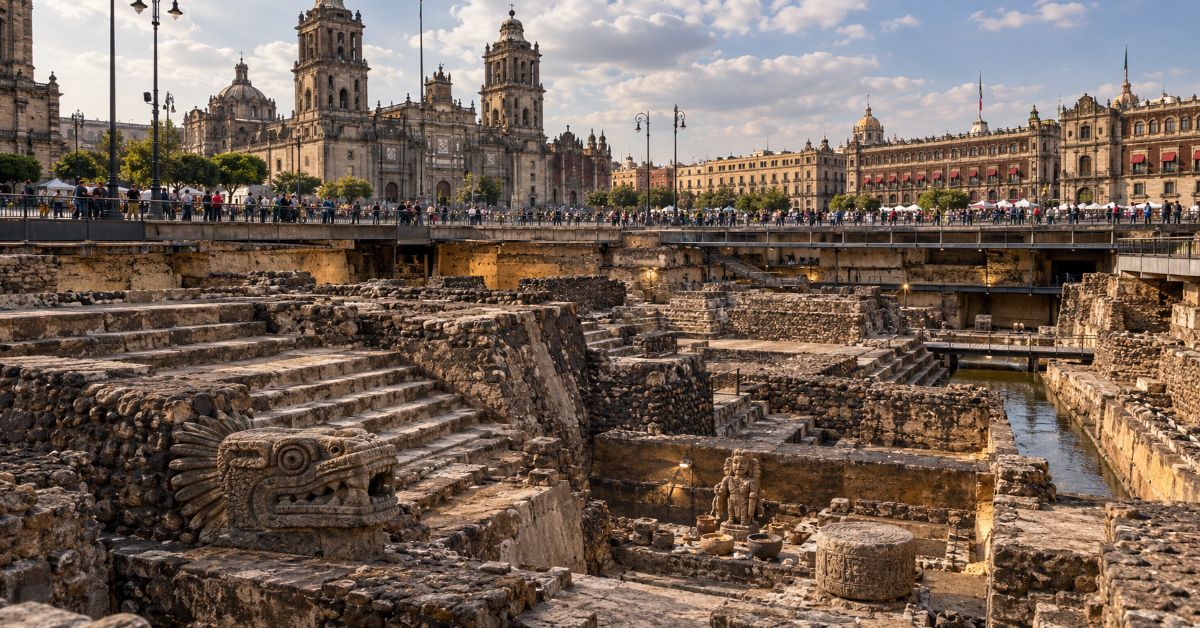
Tenochtitlan was the island capital of the Mexica and the political core of the empire usually called Aztec, but the most important fact about it in 2026 is that the city is not finished history: archaeologists are still mapping and excavating it beneath central Mexico City. The ruins of its main temple sit beside the Metropolitan Cathedral, while new research continues to identify buried foundations, offerings and ritual spaces under streets that carry modern traffic.
That overlap changes the usual story. Tenochtitlan is often reduced to three scenes: an eagle on a cactus, a spectacular city encountered by Hernán Cortés, and a final siege in 1521. All three matter, but they can hide the harder questions. How confidently can a founding date be assigned? How did a dense capital survive on a lake? How much food was produced inside the city rather than brought in? Why did surrounding Indigenous powers ally with the Spaniards? And how much of the pre-Hispanic city can still be reconstructed when a colonial and modern metropolis was built directly on top of it?
This guide treats the city as a system rather than a legend. It follows the movement from migration traditions and early settlement to water engineering, imperial power, daily life, conquest and the archaeology still changing the picture. It also separates well-supported evidence from popular shorthand, especially around the word “Aztec,” population size, chinampas and the symbolic founding date.
A Capital Born from History, Memory and Political Myth
The Mexica were Nahuatl-speaking migrants who entered a Valley of Mexico already occupied by established city-states. Their later histories described a long migration from Aztlan and a divine sign identifying the place where their capital should be founded. The eagle, cactus and water imagery eventually became central to Mexican national symbolism, but the surviving accounts were written after the conquest and combine political memory, sacred narrative and chronology.
Why 1325 is both useful and incomplete
Most Mexica historical traditions place the foundation in the year 2-House, conventionally correlated with 1325. Recent discussion by UNAM historians still treats that date as the dominant tradition, while stressing that cities emerge through long social and political processes. Archaeologist Eduardo Matos Moctezuma made that point explicitly in a 2026 lecture on the 700-year commemoration. UNAM’s 2026 discussion of the founding tradition is therefore more useful than presenting 1325 as an exact construction start date.
The evidence also shows earlier occupation around the island zone. Archaeological work beneath the cathedral and nearby buildings has found pre-Mexica material, which means the landscape was not an empty stage waiting for a new city. The founding story is best read as the moment the Mexica claimed a permanent political and sacred center, not the first human activity at the site.
| Popular claim | What the evidence supports | Why the distinction matters |
| Tenochtitlan was founded on one exact day in 1325 | 1325 is the dominant traditional date, but sources differ and urban formation was gradual. | Avoids turning a mytho-historical date into false precision. |
| The “Aztecs” were one uniform people | The residents of the capital were Mexica; “Aztec” is a later umbrella term often used for the Triple Alliance and related Nahua groups. | Clarifies identity, politics and whose city is being discussed. |
| The island was empty before the Mexica | Archaeology points to earlier activity and occupation in the area. | Places the city inside a longer Basin of Mexico history. |
| The eagle-and-snake image is unchanged from the earliest accounts | Early versions vary; the foundational symbol developed across sources and later national use. | Separates modern national iconography from the diversity of older traditions. |
How Tenochtitlan Worked as a Lake City
The achievement of the capital was not that the Mexica “defeated” the lake. They learned to organize urban life around it. Water was transport, boundary, food system and threat at the same time. Streets and canals divided neighborhoods, canoes moved people and goods, causeways connected the island to the mainland, and aqueducts brought fresh water from springs outside the saline lake environment.
Causeways, canals and fresh water
The Metropolitan Museum of Art describes three raised causeways linking the city to shore and two aqueducts supplying fresh water. That infrastructure mattered because Lake Texcoco itself could not simply be treated as a drinking-water reservoir. Dikes and hydraulic works also helped manage water levels and separate waters of different salinity. The city’s form therefore depended on constant maintenance rather than one spectacular engineering project.
Chinampas were productive wetland fields, not loose rafts
The phrase “floating gardens” survives because it is memorable, but it is misleading if taken literally. Chinampas were constructed wetland plots built from soil, vegetation and lake sediment, usually stabilized in shallow water and integrated with canals. They could be extremely productive, yet scholarship also warns against assuming that urban chinampas alone fed the entire capital. Tenochtitlan depended on a much wider regional supply network, tribute system and market economy.
| Urban system | Function | Constraint or trade-off |
| Canals | Moved people, food, tribute and building materials by canoe. | Required dredging, water-level management and navigable connections. |
| Causeways | Connected the island city to surrounding shores. | Could become military chokepoints during siege. |
| Aqueducts | Delivered fresh spring water. | Created dependence on infrastructure outside the island core. |
| Chinampas | Produced crops in wetland plots and expanded usable land. | Did not remove dependence on regional food and tribute flows. |
| Dikes and reclaimed land | Managed flooding and supported urban expansion. | Altered hydrology and required ongoing labor. |
From Vulnerable Settlement to Imperial Center
Tenochtitlan’s rise was political before it was imperial. The Mexica were initially subordinate to stronger powers in the basin. The decisive shift came in the 1420s, when Tenochtitlan allied with Texcoco and Tlacopan against Azcapotzalco. The resulting Triple Alliance expanded through warfare, tribute and strategic control of trade routes. Over time, Tenochtitlan became the dominant partner.
That distinction matters because “Aztec Empire” can imply a centralized state resembling later European empires. In practice, power was uneven. Conquered communities could retain local rulers and institutions while owing tribute and military obligations. This created wealth for the capital but also resentment, which became strategically important when Cortés entered the region in 1519. Spanish victory was not a simple contest between a few Europeans and a unified Indigenous empire; it depended heavily on Indigenous allies with their own political goals.
Templo Mayor turned political power into sacred geography
At the center of the sacred precinct stood the Templo Mayor, repeatedly enlarged and dedicated principally to Huitzilopochtli and Tlaloc. The structure linked war, tribute, rainfall, agricultural fertility and dynastic authority. INAH notes that the temple was rebuilt over earlier stages at least seven times, preserving the same basic orientation and twin-shrine arrangement. INAH’s Templo Mayor archaeological description makes the layering literal: each expansion enclosed earlier sacred architecture.
The City Beyond the Monumental Core
The ceremonial precinct dominates surviving imagery, but most residents did not live inside it. The city was divided into neighborhoods associated with local temples, occupations, kin groups and community obligations. Craftspeople produced ceramics, stonework, textiles and featherwork; merchants moved goods through long-distance networks; farmers worked wetland plots and nearby agricultural zones; soldiers and priests occupied different institutional roles.
The market at neighboring Tlatelolco was especially important. Tlatelolco was closely connected to Tenochtitlan but had its own political history and should not be treated as merely another neighborhood from the beginning. By the time of Spanish contact, the twin urban zone formed an enormous commercial and population center.
How many people lived there?
Popular accounts often repeat a single number such as 200,000 or 300,000. The safer formulation is a range. Archaeological and historical syntheses commonly place early-16th-century Tenochtitlan-Tlatelolco around 100,000–200,000 inhabitants, while some public-facing sources use higher estimates. Whatever precise figure is chosen, the city ranked among the largest urban centers in the Americas and compared in scale with major European capitals of the period.
Why the City Fell in 1521
The collapse of Tenochtitlan cannot be explained by firearms or steel alone. Cortés entered a politically divided region and built alliances with Indigenous groups, most importantly Tlaxcalans, who supplied knowledge, logistics and large numbers of warriors. Internal conflict intensified after the Spaniards seized Moctezuma II, and violence in the city led to the Spanish retreat of 1520.
Disease then changed the balance. Smallpox spread through populations with no previous exposure, killing residents and leaders and disrupting defense. When the attackers returned in 1521, they combined land forces, Indigenous allies and brigantines on the lake. They cut water and supply routes, fought along causeways and canals, and gradually destroyed the city’s ability to resist. Cuauhtémoc was captured on August 13, 1521.
Calling this the “Spanish conquest” is not wrong, but it is incomplete if it erases the tens of thousands of Indigenous combatants who fought against Mexica power or the epidemic that devastated the defenders. The fall was military, political, biological and logistical at once.
The Most Important Story Is What Archaeology Is Still Finding
After 1521, Spanish authorities built the capital of New Spain over the damaged Mexica city. Temples were dismantled, canals changed, and later drainage projects transformed the lake system. Yet the new city did not erase the old one cleanly. Foundations, offerings and sacred architecture remained beneath colonial and modern layers.
1978 changed the scale of research
On February 21, 1978, electrical workers uncovered the monumental Coyolxauhqui sculpture near the cathedral. The discovery triggered the modern Proyecto Templo Mayor under Eduardo Matos Moctezuma and opened a sustained program of excavation in the ceremonial center. INAH describes the project as a turning point that exposed successive temple phases, the House of the Eagles, Cuauhxicalco and major ritual deposits.
2025–2026 research is moving from objects to urban reconstruction
Recent work shows how much the research agenda has expanded. In 2025, Mexican cultural authorities reported advanced bioarchaeological and isotope studies on a sample of 214 skulls associated with the Huei Tzompantli. In February 2026, INAH announced offerings containing 83 Mezcala-style figurines tied to a large ritual event during the reign of Motecuhzoma Ilhuicamina. These finds help connect imperial expansion, ritual practice and the movement of objects across Mesoamerica.
In July 2026, INAH also reported its first altimetric survey across the area of the former sacred precinct, recording elevation differences, cracks and building inclinations to help model buried pre-Hispanic foundations beneath the historic center. INAH’s 2026 altimetric survey announcement This is a crucial shift: archaeology is not only recovering artifacts; it is using the behavior of the modern city itself to infer the geometry of the city below.
| Date | Finding or project | What it changed |
| 1978 | Coyolxauhqui monolith discovered; Proyecto Templo Mayor launched. | Made large-scale modern excavation of the sacred precinct possible. |
| 1991 onward | Programa de Arqueología Urbana formalized work across central properties. | Extended research beyond one temple into a buried urban landscape. |
| 2015–2025 | Huei Tzompantli research and laboratory analysis. | Shifted attention from a skull-rack monument toward the biographies and origins of individuals. |
| February 2026 | Offerings 186, 187 and 189 linked to a large 15th-century ceremony. | Connected ritual deposits with imperial expansion and Mezcala-style objects. |
| July 2026 | First altimetric survey of the former sacred precinct. | Used modern elevation and structural deformation to model buried architecture. |
What Remains of Tenochtitlan Today
The most visible remains are around the Templo Mayor archaeological zone beside Mexico City’s cathedral and Zócalo, but the surviving city is larger than the excavated trench. Archaeological windows, foundations under colonial buildings, recovered sculpture, museum collections and the street grid all preserve fragments of the earlier urban system.
UNESCO’s World Heritage description is especially useful because it treats the historic center as a layered city rather than two separate ones. It notes that colonial Mexico City was built over the ruins of Tenochtitlan and that parts of the later urban grid retained the structure imposed by the pre-Hispanic city. UNESCO’s Historic Centre of Mexico City and Xochimilco entry The surviving chinampa landscape of Xochimilco also preserves part of the wider lake-based environmental logic that made the Mexica capital possible.
That continuity is why the city is better understood as an urban palimpsest. Conquest changed ownership, religion, architecture and hydrology, but it did not create a completely new geographic center. Mexico City inherited and transformed the same strategic basin, sacred core and transport geography.
What the Current Search Results Commonly Miss
A review of ten prominent current pages and close-intent results found strong coverage of the founding legend, Templo Mayor, city size, daily life and the Spanish siege. The recurring weakness is that many pages treat Tenochtitlan as a closed historical object. They rarely connect the familiar narrative to the archaeology still changing in 2025–2026, and they often repeat disputed or simplified claims as settled facts.
- The founding date is usually presented as a precise event rather than a dominant historical tradition with competing chronologies.
- “Aztec” and “Mexica” are often used interchangeably without explaining what each term does and does not mean.
- Chinampas are frequently called floating gardens without explaining their constructed wetland form or the city’s dependence on regional supply networks.
- Population is often reduced to one dramatic number instead of a defensible range.
- The conquest is sometimes framed as Spaniards versus Aztecs, minimizing Indigenous alliances and the role of epidemic disease.
- Recent INAH research is usually absent, even though it directly changes how the buried city can be reconstructed.
The Future of Tenochtitlan in 2027
The next phase of research will probably be less about uncovering one giant monument and more about integrating many small datasets: elevation, subsidence, rescue excavations, construction records, bioarchaeology, isotope analysis, ceramics and colonial maps. The 2026 altimetric work points in that direction because it treats cracks and uneven ground in the modern historic center as evidence that can help locate buried masses below.
That approach has practical limits. Archaeologists cannot clear the center of Mexico City to reveal an ancient plan. Work must coexist with housing, utilities, heritage buildings, transit and active streets. This makes non-invasive survey, targeted excavation and digital reconstruction more important than broad exposure.
There is also a preservation tension. The same geological conditions that protect some buried remains create risks for buildings above them. UNESCO already identifies geological vulnerability, development pressure, changing land use and contamination as threats to the historic center and Xochimilco. In 2027, the most useful progress will come from treating archaeology, conservation and urban infrastructure as one problem rather than separate disciplines.
Key Takeaways
- Tenochtitlan was the Mexica capital and the dominant city of the Triple Alliance, not simply a generic “Aztec city.”
- 1325 is the traditional founding date, but the settlement developed through a longer process and surviving sources do not all agree.
- The city’s power depended on water engineering, regional food systems, tribute, trade and labor as much as monumental architecture.
- Chinampas were engineered wetland fields and should not be imagined as gardens freely floating around the lake.
- The 1521 defeat resulted from Indigenous alliances, siege logistics, political fractures and disease as well as Spanish weapons.
- Modern archaeology has been transformed by the 1978 Coyolxauhqui discovery and continues through urban excavations and laboratory analysis.
- The buried city still matters because modern Mexico City physically occupies and preserves parts of the same urban landscape.
Conclusion
Tenochtitlan deserves more than a before-and-after story in which a brilliant city appears in 1325 and disappears in 1521. Its rise came from political adaptation, regional alliances, tribute and sophisticated management of a difficult lake environment. Its fall came from a convergence of military pressure, Indigenous opposition, epidemic disease and the deliberate destruction of urban infrastructure.
Yet the strongest reason to keep studying the city is that it did not vanish. The sacred precinct remains under one of the busiest historic centers in the Americas. Every excavation, utility project and survey has the potential to add another piece to a map that can never be exposed all at once. That makes Tenochtitlan both an ancient capital and a modern research problem: a city whose past survives inside the structure, ground movement and archaeology of another city built above it.
Frequently Asked Questions
What was Tenochtitlan?
Tenochtitlan was the capital of the Mexica and the dominant city of the Triple Alliance in central Mexico. It stood on islands and reclaimed land in Lake Texcoco, where central Mexico City is today. It served as a political, religious, military and commercial center until its defeat in 1521.
When was Tenochtitlan founded?
1325 is the traditional founding year most often accepted from Mexica historical sources, especially the year 2-House. However, sources differ, and archaeology suggests that settlement and urban formation were processes rather than a single event on one exact date.
Was Tenochtitlan really built on a lake?
Yes. The capital developed on islands and reclaimed zones within Lake Texcoco. Causeways linked it to the mainland, canals supported transport, and aqueducts brought fresh water. The lake setting shaped nearly every part of the city’s growth and defense.
Were the chinampas floating gardens?
Not in the simple sense of rafts drifting on water. Chinampas were engineered wetland plots built up with soil, vegetation and sediment, usually stabilized in shallow lake zones and separated by canals. “Floating gardens” is a convenient label but can create the wrong mental picture.
How large was Tenochtitlan?
Estimates vary. Scholarly syntheses commonly place Tenochtitlan-Tlatelolco at roughly 100,000–200,000 inhabitants in the early 16th century, while some public sources use higher figures. The exact number is uncertain, but it was clearly one of the largest cities in the pre-Columbian Americas.
Why did Tenochtitlan fall?
The city fell after a 1521 siege led by Hernán Cortés with major support from Indigenous allies. Smallpox, disrupted food and water supplies, political divisions and sustained fighting all mattered. Spanish technology alone does not explain the result.
Can Tenochtitlan still be seen in Mexico City?
Yes, but only in fragments. The Templo Mayor archaeological zone is the most prominent exposed site. Other remains survive beneath streets and colonial buildings, in archaeological windows and museums, and in the inherited urban geography of the historic center.
Methodology
Research was conducted on October 7, 2026. For competitive review, ten prominent current results and close-intent pages were examined: Wikipedia, World History Encyclopedia, National Geographic Education, National Geographic History, HISTORY, ThoughtCo, The Metropolitan Museum of Art, Khan Academy, Smarthistory, and INAH/Templo Mayor institutional pages. Search order varies by location, device, personalization and time, so this is a competitive sample rather than a claim that every user sees the same permanent top ten.
The recurring SERP strengths were basic chronology, founding legend, monumental architecture, daily life and conquest. The clearest gaps were source uncertainty around the founding date, imprecise use of “Aztec” versus “Mexica,” literal treatment of “floating gardens,” single-number population claims, underweighting of Indigenous alliances, and weak coverage of 2025–2026 archaeology. This article was structured around those gaps rather than following any competitor’s section order.
Primary and institutional validation prioritized Mexico’s Instituto Nacional de Antropología e Historia (INAH), the Museo del Templo Mayor, UNESCO and UNAM. The Metropolitan Museum of Art and peer-reviewed archaeological literature were used for stable urban and population context. Older sources were retained only where they remain useful for stable historical interpretation.
This article was drafted with AI assistance and reviewed by a human editor before publishing. All data, citations, and claims have been independently verified against primary sources.
References
Museo del Templo Mayor, INAH. (n.d.). Proyecto Templo Mayor.
Museo del Templo Mayor, INAH. (n.d.). Zona Arqueológica del Templo Mayor.
UNESCO World Heritage Centre. (n.d.). Historic Centre of Mexico City and Xochimilco.
King, H. (2004). Tenochtitlan. Heilbrunn Timeline of Art History, The Metropolitan Museum of Art.